Geography
Intent
At RPA it is our intention that our coverage of the humanities subjects will provide children with a broad range of knowledge across History, Geography and RE. Our curriculum has been designed to link, where possible, our foundation subjects into termly themes, which allow our learners to link to our teaching of English and Reading and fully immerse their children into key ideas. We hope that our curriculum for the humanities subjects has been designed in such a way that the children are able to learn both knowledge and skills which will help them to progress as learners. We intend for the children to learn both about religions and history, but also to support them to form their own ideas and to learn from it, through discussion and investigation.
Implementation
- The foundation subjects typically follow the suggested order of the National Curriculum, and our offer has been planned in house to offer a broad range of subject areas within Geography. Alongside these progression grids, teachers follow a curriculum map for geography.
- In RE, we follow the Gloucestershire RE syllabus which give the children a broad range of knowledge and thinking skills related to a range of religions and beliefs.
- Planning for each subject is linked to a termly theme, and foundation subjects are often linked to this, however our foundation subjects are taught discretely.
- Teachers planning is responsive to the needs of the learners in their class, and based upon progression in understanding and skills grids which have been produced for each subject area. This ensures our learners get a broad knowledge of each topic within the foundation subjects, but also understand how to use sources, understand chronology, and discuss the causes of events.
- Due to the demographic and location of the school, much of our geography planning encourages children to think about the wider world and learn about cities and countries to give them a broader understanding of different cultures.
- Attainment is monitored through use of our progression grids within each area.
- Teaching of the foundation subjects is differentiated according to the needs of our learners to enable every child to access and engage with the content offered.
Impact
The result of our teaching is that our children will leave Redmarley with a strong understanding of both the skills and knowledge set out in the National Curriculum for the foundation subjects. In addition, that they can form opinions based on facts learned, and apply broader skills to other areas of their learning, such as investigation and discussion of sources.
Our foundation subjects offer our learners an opportunity to learn about the wider world, and the impact of key events on our current society. They are able to discuss historical events with respect and compassion and make links between their learning.
It is our clear aim that the children will gain a broad knowledge, but also learn the skills to think independently and assess information given so that they are able to form their own opinions.
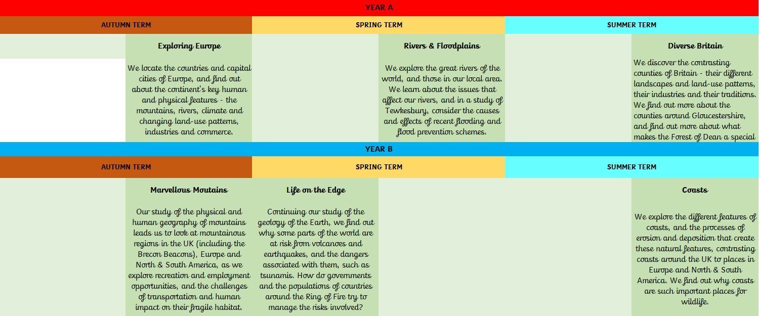
Below you can see our Geography curriculum over a two-year cycle. We are currently in Year A.
Note: Some units may change position while we adjust to the new cycle of planning.
Class 2:
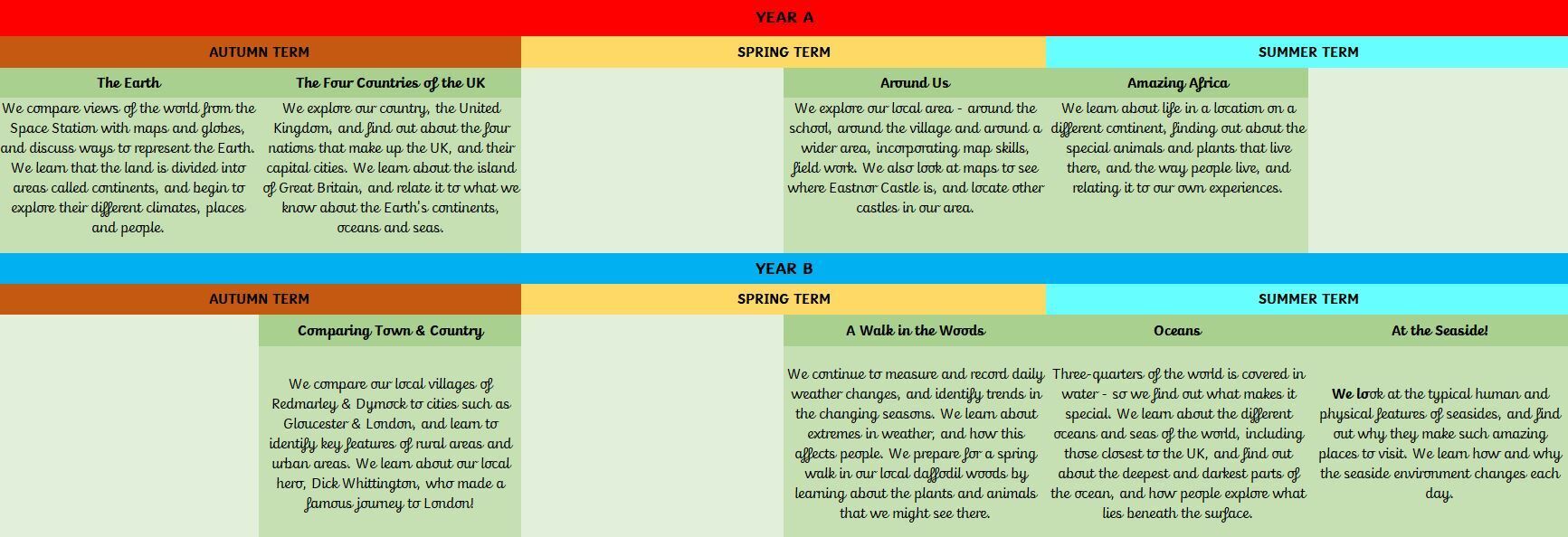
Class 3:
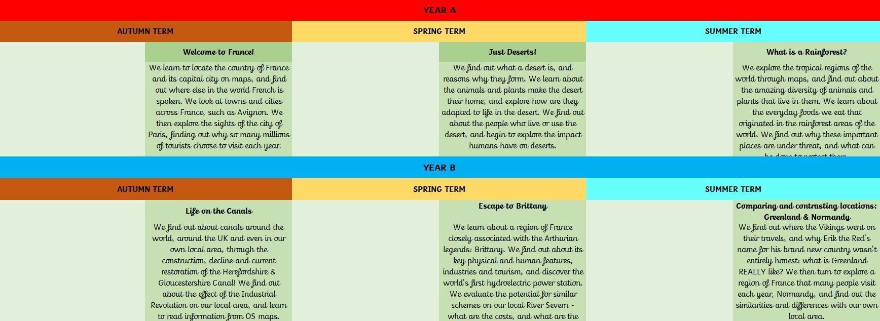
Class 4